


May 2: Wildfires and Smoke
Being prepared for wildfire smoke requires close coordination across federal, state, local and tribal air quality and health agencies. In previous AQAWs, we have featured the work of federal partners as well as cross-government partners, such as the Air Resource Advisors of the Interagency Wildland Fire Air Quality Response Program. This year we feature the work of a local government agency in Placer County, California to describe how it is Air Aware & Prepared for wildfire smoke.
Wildfire Smoke in Placer County, CA
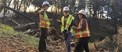 Smoke from wildfires significantly impacts air quality in Placer County and beyond every year, causing increased particle pollution in the air. Each year when the weather warms and vegetation dries out, the staff from the Placer County Air Pollution Control District
  (District) begin preparations for wildfire smoke and how to help the public better protect their health and reduce their exposure.
Smoke Information for the Public
On days with prolonged smoke impacts or when smoke impacts are forecasted during the summer and fall months, District staff issue air quality advisories in conjunction with the county’s health officer. Air quality advisories are based on the District’s evaluation of air monitoring data from both our existing fixed monitoring network as well as low-cost sensors and weather forecasts provided by the National Weather Service. The advisories include useful information and various resources for residents and the public to use on how to reduce their smoke exposure.
Check out an example of an air quality advisory here: https://www.placer.ca.gov/7468/Joint-air-quality-advisory
Placer Country Air District has also created a mask information guide and outdoor activities guide for the public.
Smoke Information for Schools and Students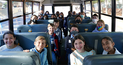
Smoke can also greatly impact students in school. District staff work in conjunction with the Placer County Office of Education (PCOE) and Placer County Health and Human Services staff to make sure current information is available to the public when smoke impacts occur. This includes information on students’ exposure to smoke, the school activities guide, and online air quality tools for decision making, such as the Fire and Smoke map.
California Smoke Blog has Key Up-To-Date Information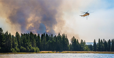
The California Smoke Blog was created by District staff during the American Fire in 2013. This go-to site has grown into a statewide resource on wildfire smoke. Smoke Outlooks, collaborative information, and fact sheets from EPA, U.S. Forest Service (USFS), and the Centers for Disease Control and Prevention (CDC) have been included in the Smoke and Health section along with information from other air quality and health agencies:
- Smoke and Health Fact Sheets and Information (English)
- Humo y Salud Páginas de Hechos e Información (Español)
Spanish information was added to the Blog in 2021.
Wildfire Resources Can Also Be Used for Prescribed Fires
Prescribed fire is a land management tool that can reduce the likelihood of catastrophic wildfires by strengthening an area’s ecosystems and reducing the buildup of unwanted fuels/vegetation. In contrast to wildfire, prescribed fire is a planned event with coordination and advanced notification so communities and individuals can take health protective actions to reduce exposure. Though a prescribed fire has the potential to reduce the likelihood and severity of a future wildfire, both events produce smoke and may result in public health impacts.
[Read more about air quality and health impacts of smoke from prescribed fires and wildfires here: “Comparative Assessment of the Impacts of Prescribed Fire Versus Wildfire (CAIF): A Case Study in the Western United States”]
To help reduce future wildfire smoke, Placer County Air District staff actively work on prescribed burning smoke management. With an expected increase in using prescribed fire for vegetation management, there may be smoke at different times during the year. The same resources for wildfire smoke impacts can help you protect yourself if prescribed burn smoke impacts occur. Being Air Aware and Prepared with local wildfire and prescribed fire smoke info allows you to make better decisions for your health.
Fire and Smoke Map Updates
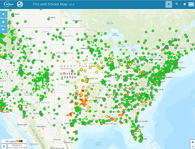 EPA and USFS have continued working on and improving the Fire and Smoke Map for 2022. This map allows people to visualize how smoke from a wildfire may impact an area. The map displays information from ground- level air quality monitors as well as sensors recording fine particles (PM2.5) from smoke.
The Placer County Air District staff worked with the Placer County Communication staff to create an instructional video on using the Fire and Smoke Map .
Recent improvements
The Fire and Smoke Map team has added a new map layer to optimize it for a wide variety of users who have color vision deficiency. The new layer uses a color vision assist approach from the California’s South Coast Air Quality Management District to show the map in a modified Air Quality Index color scale. To access the translation or the color vision assist map layer, click the globe icon at the top right of the map.