


May 7: Air Quality Around the World
BACKGROUND
Air Quality Awareness Week partners work with countries around the world to better understand air quality. The U.S. Department of State, NASA and EPA are engaged in a variety of efforts to better understand the impact of air pollution sources outside the United States on health and environmental quality in the United States, and to enable and motivate the mitigation of these sources in other countries.
Below you can learn more about different projects currently happening around the world!
 WHAT'S HAPPENING
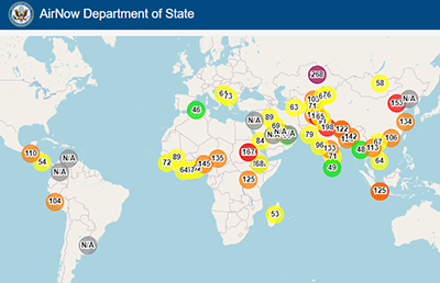
Global Air Quality
Over 80 percent of U.S. embassies and consulates are in cities where PM2.5 (particulate matter 2.5 microns or smaller in diameter) exceeds the U.S. Environmental Protection Agency (EPA) annual air quality standard. Yet in many of these locations, real-time, reliable air quality data are unavailable.
To help address this problem, U.S. Embassy Beijing installed a reference-grade air quality monitor in 2008. Since then, more than 60 other U.S. embassies and consulates have followed suit. Having access to accurate, real-time data is a critical step to enable people to take action to reduce their exposure and improve the health, safety, and well-being. The U.S. Department of State’s air quality monitoring program utilizes the same high-quality equipment, data collection, and reporting criteria used in the United States which is based on decades of EPA technical and policy experience and expertise. This rigorous monitoring and reporting also serves as an objective model for foreign audiences, sometimes spurring local action to improve air quality. With the support of the EPA, U.S. embassy and consulate data are made widely available through the AirNow platform: https://www.airnow.gov/international/us-embassies-and-consulates/.
New in 2020, the U.S. Department of State released ZephAir, an air quality app for mobile phones that leverages EPA health messaging and data from the Department of State’s reference-grade monitors to provide easy access to vital air quality information.
Satellite Monitoring
 While the health risks of particulate matter (PM) air pollution have been well established by epidemiologists, data remain scarce on the relative health impacts of particles with different sizes, shapes, and compositions. NASA’s Multi-Angle Imager for Aerosols (MAIA) investigation aims to explore the effects of exposure to different types of PM on human health, using satellite instruments, surface monitors, atmospheric modeling and public health databases. Find out more about the MAIA project at https://maia.jpl.nasa.gov/ and https://climate.nasa.gov/news/3027/getting-to-the-heart-of-the-particulate-matter/.
Megacities Partnership – Ethiopia
 The Addis Ababa Environmental Protection and Green Development Commission (AAEPGDC) has developed a draft integrated air quality management plan that identified priority programs to reduce air pollution emissions. The goal is to create a sustainable policy environment in which AAEPGDC can undertake ongoing environmental planning and serve as regional experts, providing peer-to-peer support for other countries.
Learn more about recent developments with the Ethiopia Megacities Partnership.
Megacities Partnership – Peru
Peru’s Ministry of the Environment, in collaboration with EPA’s Megacities Partnership, recently completed an air pollution study in the Lima-Callao region. Analysis of the local pollution conditions revealed that over 10,000 premature deaths each year likely resulted from PM2.5 exposure, at a cost of $1.5 million USD. To address PM2.5 levels, the report recommended increased enforcement of current vehicle emission standards, as well as expanding the region’s vehicle Inspection & Maintenance programs.
Learn more about recent developments with the Peru Megacities Partnership.
Transboundary Air Quality – U.S./Mexico Border
 In partnership with U.S. EPA, the California Air Resources Board and the Imperial County Air Pollution Control District are developing an air quality website and mobile application that provides public access to real-time local air quality data, air alerts, air quality forecasting, and health impact information.
Recently, the Joint Advisory Committee (JAC) for Improvement of Air Quality in the El Paso, TX / Juarez, Chihuahua / Doña Ana County, NM air basin, established a first-of-its kind binational fund that will support air quality projects near the U.S.-Mexico border.
Learn more about recent air quality developments along the U.S./Mexico Border.
OTHER RESOURCES
 ZephAir gives members of the public, including the U.S. Department of State’s 90,000 employees, 50,000 family members, and millions of U.S. citizens living and travelling abroad, access to reliable, actionable, and relevant information that can assist in protecting their health. The app includes customizable features such as push notifications and preferred locations, allowing for quick and convenient updates on air quality information in your area. ZephAir is available for download on the Google Play and Apple App stores.
Android: https://play.google.com/store/apps/details?id=gov.state.apps.android.dosair&hl=en&gl=US
Apple: https://apps.apple.com/us/app/zephair/id1518837988